Niagara Falls formed after the last Ice Age, when melting glaciers helped shape the Great Lakes and sent water flowing from Lake Erie toward Lake Ontario. As that water crossed the Niagara Escarpment, it began cutting through layers of ancient rock, creating the waterfalls, gorge, rapids, and dramatic river landscape visitors see today.
The falls feel timeless when you stand beside them, but geologically speaking, they are young. The rocks beneath Niagara are hundreds of millions of years old, while the waterfall itself began forming about 12,000 to 12,500 years ago. Its story is a meeting of old stone, retreating ice, fast water, and steady erosion.
Niagara Falls Began With Ancient Rock
Long before there was a Niagara River, the region was covered by ancient seas. Over millions of years, layers of sediment settled on the sea floor and hardened into rock. Around Niagara, those layers include limestone, dolostone, shale, sandstone, and other sedimentary rocks.
These rocks became part of the Niagara Escarpment, a long ridge-like landform that stretches through parts of New York, Ontario, Michigan, Wisconsin, and Illinois. In the Niagara region, the escarpment created the drop that allowed the river to become a waterfall.
The most important detail is that the rock layers do not all wear away at the same speed. Harder upper layers resist erosion better, while softer layers below them can be undercut by rushing water. That difference helped Niagara Falls keep its steep, vertical shape instead of becoming a gentler river slope.
In simple terms, Niagara Falls formed where powerful water met the right kind of rock: a resistant cap above weaker layers that could slowly be worn away.
The Ice Age Set the Stage
The next major part of the story came much later, during the last Ice Age. Thick ice sheets covered Southern Ontario and parts of the surrounding Great Lakes region. As the ice moved, it helped gouge out lake basins and reshape the land.
When the climate warmed, the ice retreated northward and released vast amounts of meltwater. That water filled the Great Lakes basins and began searching for routes toward the Atlantic Ocean.
The Niagara Peninsula became free of ice about 12,500 years ago. As meltwater moved through the region, it flowed through what became Lake Erie, the Niagara River, Lake Ontario, the St. Lawrence River, and eventually the Atlantic Ocean. At first, there were several spillways between Lake Erie and Lake Ontario, but over time the flow concentrated into the route that created the original Niagara Falls.
The glaciers did not carve the modern falls in one simple cut. Instead, they created the conditions that made the falls possible: the Great Lakes basins, the meltwater supply, and the drainage route that became the Niagara River.
The Niagara River Began Flowing Over the Escarpment
Once water began moving from Lake Erie toward Lake Ontario, it crossed the Niagara Escarpment near the Queenston-Lewiston area. That is where the first version of Niagara Falls formed, several miles downstream from the current brink.
This is one of the most important facts about Niagara’s formation: the falls did not begin where visitors see them today. They started near the escarpment and slowly moved upstream as erosion cut into the bedrock.
The Niagara River became the link between Lake Erie and Lake Ontario. As water poured over the escarpment, it attacked the rock below, widened cracks, broke away pieces of stone, and began carving a deep channel. Over thousands of years, the falls migrated about seven miles upstream and left behind the Niagara Gorge.
How Erosion Moved Niagara Falls Upstream
Erosion is the main force that shaped Niagara Falls after the river began flowing over the escarpment. The process happened gradually, but it was powerful enough to move the waterfall miles from its original position.
Hard Rock Formed the Ledge
The harder rock near the top of the falls helped create a strong ledge. This caprock resisted erosion better than the layers below it, allowing water to plunge over a sharp edge rather than simply flow down a slope.
That hard upper layer is one reason Niagara Falls became such a dramatic cataract. It helped preserve the brink while the weaker rock beneath it wore away.
Softer Rock Wore Away Below
Below the resistant caprock are softer layers, including shale. These layers erode more easily. As water crashed over the brink, it struck the lower rock with tremendous force. Spray, turbulence, freezing and thawing, and the pressure of falling water all helped weaken the softer stone.
Over time, the lower layers were worn back underneath the harder cap. This created an overhang, where the top rock projected outward without enough support below.
Rock Collapsed and the Falls Retreated
Eventually, parts of the unsupported caprock broke away and fell into the river. Some fallen blocks collected at the base, while others were broken down and carried downstream by the force of the water.
Each collapse moved the brink slightly upstream. Repeated over thousands of years, this cycle of undercutting and collapse caused Niagara Falls to retreat from the Queenston-Lewiston area toward its present location.
How the Niagara Gorge Was Carved
The Niagara Gorge is the clearest visible record of the falls’ long retreat. It is not just a scenic canyon below the falls. It is the path left behind as Niagara Falls moved upstream through the bedrock.
Over the last 12,000 years, erosion of the resistant rocks that cap Niagara allowed the falls to move upstream and form the high-walled gorge along its former path. Today, that gorge stretches downstream from the current falls toward Queenston, Ontario, and Lewiston, New York.
The gorge walls reveal the layered rocks that made the waterfall possible. They also show why Niagara’s landscape is so dramatic: the river did not simply flow across the land, but cut deeply into it as the falls retreated.
Features such as the Whirlpool and Whirlpool Rapids add another chapter to the story. Near the Whirlpool area, the river’s path bends sharply through a landscape shaped by older drainage channels, changing rock conditions, and the continuing force of the Niagara River.
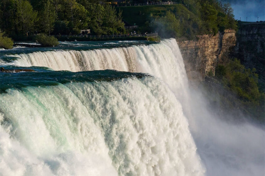
Why Niagara Falls Has Three Waterfalls Today
Niagara Falls is often described as one waterfall, but it is actually made up of three: Horseshoe Falls, American Falls, and Bridal Veil Falls.
Horseshoe Falls is the largest and carries most of the river’s flow. It sits mainly on the Canadian side and has the wide curved shape many visitors associate with Niagara. American Falls and Bridal Veil Falls are on the U.S. side.
The division happens because of islands at the brink. Goat Island separates Horseshoe Falls from American Falls, while Luna Island separates American Falls from Bridal Veil Falls. These islands split the river before it drops over the edge, creating three distinct waterfalls instead of one continuous curtain.
The shape of each waterfall also reflects the geology and flow around it. Horseshoe Falls has the most powerful volume and a deep plunge pool. American Falls has a straighter crest and a large rock pile, known as talus, at its base. Bridal Veil Falls is narrower, giving it a more delicate appearance even though it belongs to the same powerful river system.
Is Niagara Falls Still Changing?
Niagara Falls is still changing, but much more slowly than it did in the past. Natural forces continue to affect the falls, including freezing, thawing, rockfalls, water pressure, and gradual erosion.
However, modern water control has reduced the speed of that change. Water is diverted for hydroelectric power on both sides of the border, and engineering work helps manage flow over the falls. These modern influences have caused the falls to wear away less quickly than they once did.
This does not mean Niagara Falls is frozen in time. It remains an active geological feature. The difference is that today’s waterfall is also part of a carefully managed international waterway, balancing natural scenery, power generation, public safety, and preservation.
What Visitors Can See From This Formation Story
One reason Niagara’s geology is so interesting is that much of it is visible from public viewpoints, trails, and attractions. You do not need to be a geologist to notice how water and rock shaped the region.
The Niagara Gorge
The gorge shows the former path of the falls. Looking down into it, visitors can picture the waterfall slowly retreating upstream from the escarpment and carving the river corridor behind it.
Niagara Glen
Niagara Glen offers a closer look at rugged rock, boulders, and gorge terrain. It is one of the best places to sense how powerful and uneven the river landscape became as the falls cut through bedrock.
Journey Behind the Falls
Journey Behind the Falls brings visitors close to the bedrock beside Horseshoe Falls. The experience makes the formation story feel immediate: water is still pounding against the same kind of layered rock that shaped the falls over thousands of years.
Queenston Heights and Lewiston
The Queenston-Lewiston area helps explain where the falls began. Seeing how far it is from the current brink makes the seven-mile retreat easier to understand.
Quick Timeline of Niagara Falls’ Formation
| Period | What Happened |
|---|---|
| About 400 to 440 million years ago | Sediments from ancient seas hardened into the layered rocks now visible around Niagara. |
| During the last Ice Age | Glaciers covered and reshaped the Great Lakes region, carving basins and altering drainage routes. |
| About 12,500 years ago | The Niagara Peninsula became free of ice, and meltwater began moving through the Great Lakes system. |
| About 12,000 years ago | Water found a route through the Niagara Escarpment and began carving the Niagara River. |
| Early Niagara Falls | The original falls formed near the Queenston-Lewiston area. |
| Thousands of years after formation | Erosion moved the falls about seven miles upstream and carved the Niagara Gorge. |
| Today | Niagara Falls continues to erode, but water diversion and preservation work have slowed the process. |
Final Thoughts
Niagara Falls formed through a rare combination of ancient rock, Ice Age meltwater, and steady erosion. The glaciers shaped the Great Lakes region and supplied the water. The Niagara Escarpment created the drop. The river cut into softer rock below a harder cap, causing the falls to collapse, retreat, and carve the gorge over thousands of years.
That process is still part of Niagara today. The pace has slowed, but the falls remain a living geological feature shaped by water, stone, weather, and time. Every view of the brink and every walk along the gorge is a glimpse into a landscape that is still changing.